How Iceland’s Wind Patterns Affect Northern Lights Visibility — Explained Simply
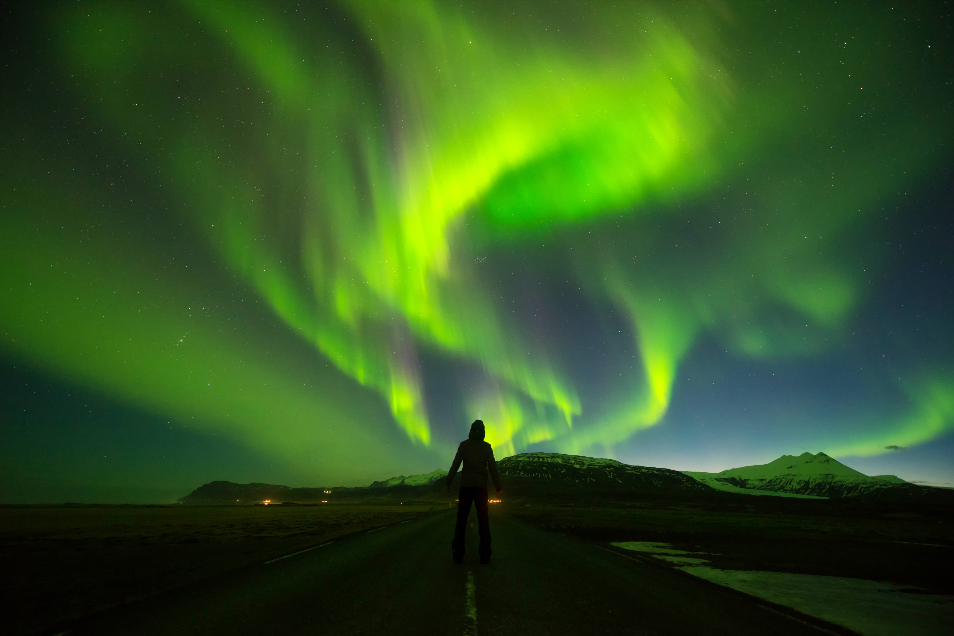
Northern lights appear unpredictable at first glance. They glow brightly one moment, fade the next and sometimes never show up despite strong forecasts. But there is one factor that has more influence on Icelandic aurora visibility than almost anything else: wind.
Wind is the quiet force shaping the sky above Iceland every hour of winter. It moves clouds, clears openings, builds fog banks and changes visibility from one neighborhood to the next. Understanding Iceland’s wind patterns does not require scientific training. It simply requires knowing what different wind directions mean for cloud behavior and how to use that information to find clearer skies.
This article explains Iceland’s wind-driven aurora visibility in simple language. You’ll learn why southern winds often hurt viewing while northern winds help, why Reykjavík can be cloudy while the countryside is clear and how to use Iceland’s natural geography to escape cloud cover quickly. By the end, you will understand the northern lights not only as a visual event, but as a natural interaction between solar energy and the movement of Iceland’s winter atmosphere.
The Simple Rule: Auroras Need Darkness and Clear Skies
Before diving into wind, it helps to remember the basics. Northern lights need two things:
- Darkness
- Clear or partly clear skies
Darkness is predictable. Cloud cover is not.
This is where wind becomes the hero or the obstacle.
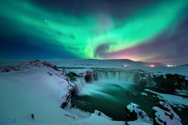
In Iceland, clouds do not sit still. They shift constantly, sometimes breaking into thin patches that reveal the auroras even when the rest of the sky is gray. A night that begins hopeless can clear within twenty minutes because a wind front pushes the cloud layer east or north.
Understanding this movement gives you an enormous advantage. It allows you to choose the best direction to drive, which locations tend to clear first and whether waiting twenty minutes is worth it.
Wind is the reason locals often see more auroras than travelers: they know where the sky opens under different wind patterns.
Why Iceland’s Wind Matters More Than in Other Countries?
Iceland is surrounded by the cold waters of the North Atlantic and is positioned directly between the frigid Arctic and warmer southern airflows. This unique geographic location makes it one of the most consistently wind-active countries on Earth.
Three things make Iceland’s wind patterns special for aurora hunting:
1. No tall forests to obstruct the wind
In many other countries, dense, tall forests act as natural barriers that block and slow down the wind. In Iceland, however, the landscape is dominated by vast lava fields, open tundra, and long stretches of coastline. Without significant tree cover, the wind flows freely and powerfully across the island, influencing the weather with great speed.
2. Sharp mountains and long fjords that create microclimates
The dramatic Icelandic topography, with its sharp mountains and deep, long fjords, plays a crucial role in shaping local weather. These natural structures don't just block wind; they actively redirect it along with the cloud layers it carries. This process creates distinct microclimates where the sky can suddenly open up, revealing clear patches even when forecasts predict overcast conditions.
3. Constant low-pressure systems that keep clouds moving
Iceland sits directly along the path of major North Atlantic storm tracks. This means the region is frequently affected by low-pressure systems that cause cloud layers to move very quickly. For aurora chasers, this is excellent news. Unlike in places where a solid bank of clouds can remain stuck for days on end, Iceland's weather is dynamic, full of shifting pockets of clarity that can appear and disappear in a short amount of time.
Ultimately, the wind controls almost all of this atmospheric movement, making it the key factor for finding those precious clear skies needed to see the northern lights.
Understanding Wind Directions: The Simple Guide
Here is an easy breakdown of what each wind direction usually means for northern lights visibility around Reykjavík and southwestern Iceland.
This explanation is simplified, but highly accurate for real-world use.
North Wind (Coming From the North):
Best for visibility on Reykjavík’s coast and western areas.
A north wind pushes clouds away from the city and across Faxaflói Bay. These winds often bring clearer skies to:
- Seltjarnarnes Peninsula
- Grótta Lighthouse
- Reykjavík’s coastline
- Akranes and Borgarfjörður
North winds also tend to bring colder air, which stabilizes cloud formation. If the aurora forecast is good, a north wind can turn Reykjavík into an excellent last-minute viewing area.
In simple terms:
North wind = clearer skies near Reykjavík’s northern and western horizons.
Northeast Wind:
Great for South Coast viewing, mixed for Reykjavík.
A northeast wind often clears the southern coastline first, including:
- Þorlákshöfn
- Selfoss region
- Hvolsvöllur
- Vík (sometimes)
Reykjavík may experience shifting cloud layers rather than full clearing, but the coastline toward Keflavík and Hafnir often improves.
In simple terms:
Northeast wind = head toward the South Coast or Reykjanes Peninsula.
East Wind:
Unpredictable but often clears inland areas.
East winds can bring cloud cover to Reykjavík but clear skies inland. Good places during an east wind include:
- Þingvellir
- Laugarvatn
- Geysir region
- Mosfellsdalur
Because Iceland’s mountains block some eastern airflow, cloud layers may break unexpectedly once you leave the capital.
In simple terms:
East wind = go inland; Reykjavík may stay clouded.
Southeast Wind:
Typically the worst for Reykjavík’s visibility.
Southeast winds often bring heavy cloud layers or precipitation. This is one of the most common wind patterns in winter, which is why Reykjavík sometimes spends whole evenings under cloud.
During southeast winds, clearer skies usually appear west or northwest of Reykjavík, including:
- Akranes
- Borgarnes
- Snæfellsnes Peninsula
In simple terms:
Southeast wind = Reykjavík clouded, go northwest.
South Wind:
Challenging for viewing in Reykjavík, but good openings occur inland.
South winds bring maritime moisture, which means thicker cloud cover. However, this wind can also create thin breaks over:
- Þingvellir
- Hvalfjörður
- Mosfellsdalur
South winds can work well if you are willing to drive inland.
In simple terms:
South wind = avoid the city center, head toward valleys and inland plains.
Southwest Wind:
One of the best for Reykjavík.
Southwest winds often push cloud layers upward and away from the city. These winds create excellent conditions for:
- Grótta
- Seltjarnarnes
- Esja foothills
- Hafnarfjörður lava fields
When the aurora forecast is good, southwest winds produce some of the brightest shows over Reykjavík.
In simple terms:
Southwest wind = prime viewing around Reykjavík.
West Wind:
Very good for the South Coast and Reykjanes.
A west wind clears the southern horizon and often leaves Reykjavík with patchy but workable skies. It is common for the auroras to appear low on the southern horizon first.
Locations that benefit:
- Þorlákshöfn
- Stokkseyri
- Reykjanes Peninsula
- South Coast beaches
In simple terms:
West wind = head south.
Why Wind Direction Isn’t Everything: Speed Matters Too?
Wind speed is a crucial factor because it controls how quickly cloud layers move across the sky, as well as how they break apart and reform over time.
Slow wind (0–5 m/s):
When the wind is slow, clouds tend to linger in one place, and any openings that form will move very slowly across the sky. This means that if it's already cloudy when you head out, there's a high chance it will remain cloudy for a while.
Moderate wind (6–12 m/s):
This is the ideal wind speed range for aurora viewing. A moderate wind keeps things dynamic, causing clouds to shift, break apart, and create temporary windows of clear sky. These openings provide opportunities to see the auroras even on a partly cloudy night.
Strong wind (13–20+ m/s):
A strong wind moves clouds very quickly, which can clear large sections of the sky in a short amount of time. Even with fast-moving clouds, auroras can often be spotted through the openings. The sky might change rapidly, but these conditions can still offer rewarding views.
Extreme wind (25 m/s and above):
At this speed, the wind itself becomes a significant factor. While it may clear the sky effectively, the viewing experience can become uncomfortable or even unsafe, particularly in exposed coastal areas where the wind is strongest.
Iceland’s Coastal Influence: Why Shores Clear Faster
The weather patterns in Iceland are profoundly shaped by the surrounding ocean, which in turn significantly influences cloud behavior, particularly along the coast. Coastal winds have a distinct effect on cloud formation and movement, largely because the ocean produces less rising warm air (thermals) compared to landmasses.
This difference in thermal activity often results in cloud layers thinning out or dissipating as they move over the ocean. Furthermore, the wind patterns near shorelines tend to push clouds horizontally, spreading them out across the sky, rather than forcing them to build up vertically into denser formations.
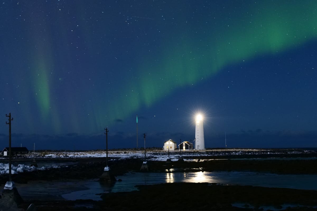
As a result of this coastal dynamic, it's common for coastlines to clear up unexpectedly, offering clear skies even when areas just a short distance inland are completely shrouded in clouds. This phenomenon is why residents of Reykjavík looking for a glimpse of the auroras often turn their attention to coastal locations. Spots like the Grótta lighthouse, the scenic Ægisíða coastline, and the expansive sky over Faxaflói Bay are well-known for providing clear windows to the sky, making them prime viewing locations.
How Mountains Affect Aurora Viewing Through Wind Behavior?
Mountains create shadow zones in the atmosphere.
When wind hits a mountain range, it:
- Splits
- Rises
- Drops moisture
- Creates a clear patch on the downwind side
Where this effect happens near Reykjavík:
Esja Mountain
When northern or northeastern winds hit Esja, the downwind side (Reykjavík direction) sometimes clears for short periods.
Bláfjöll and Reykjanes mountains
Southern winds interacting with these mountains can clear the area around Hafnarfjörður and the lava fields.
Heiðmörk
Its elevation and terrain often sit above low cloud layers.
Mountains reshape cloud cover dramatically in Iceland. A twenty-minute drive can take you from full cloud to an open sky.
Microclimates: The Hidden Reason Visibility Changes Within Minutes
A microclimate is a small area with different weather than its surroundings. Iceland has hundreds of them because of:
- Lava fields
- Hot springs
- Mountains
- Coastlines
- Valleys
These microclimates create “pockets of clarity” where auroras become visible even when satellite maps suggest full cloud cover.
Examples around Reykjavík:
Elliðaárdalur Valley
Often clearer than the surrounding neighborhoods because cold air settles and stabilizes low clouds.
Rauðhólar volcanic area
Wind patterns around the craters break up low cloud layers.
Mosfellsdalur
A sheltered valley with frequent sky openings.
Reykjanes Peninsula
Wind funnels between mountains and coastline, dispersing cloud layers.
Using microclimates effectively is the secret behind many last-minute aurora sightings.
How to Read Iceland’s Sky Quickly Using Wind?
You don’t need any special tools or apps to understand wind. Your eyes already provide all the information you need to make quick and confident observations.
Start by watching the direction of cloud movement. The way clouds drift can indicate where clearer skies might be coming from. Pay attention to the thickness of the clouds as well—thin, fast-moving clouds often break apart quickly, signaling potential changes in weather.
Look for gaps between cloud layers. When multiple layers of clouds move in different directions, it often creates sudden openings in the sky. Lastly, check the brightness near the horizon. A faintly lighter northern horizon can mean that the clouds are thinning.
By using these simple techniques, you can assess the wind and weather patterns in just a few minutes, no tools required.
Using Wind to Plan Last-Minute Aurora Trips
Here is a simple step-by-step method anyone can use.
Step 1: Check the Wind Direction
Use an Icelandic weather website (like Vedur) or simply feel it outdoors.
Step 2: Match the Wind to the Best Regions
Use the guide from earlier:
- North wind → Reykjavík coast
- East wind → Inland valleys
- Southeast wind → West Iceland
- Southwest wind → Reykjavík & surroundings
Step 3: Look at Cloud Maps
Find areas with thinner patches or areas where the wind pushes cloud layers apart.
Step 4: Choose a Direction, Not a Destination
Aurora success often comes from flexibility, not commitment.
Drive or walk toward the clearer horizon.
Adjust as the sky changes.
Step 5: Stay Patient for 20 Minutes
Wind often opens short windows.
A little patience becomes your biggest advantage.
Real Examples of How Wind Can Reveal Auroras?
Scenario 1: Reykjavík fully cloudy, but north wind blowing
Clouds begin drifting south.
Openings appear above Grótta.
Auroras appear low on the horizon first.
Scenario 2: Southeast wind and heavy cloud cover
Reykjavík stays cloudy.
Drive northwest toward Akranes.
Sky clears rapidly behind the mountain barrier.
Scenario 3: Weak wind and stagnant clouds
Openings appear inland where elevation rises.
Þingvellir and Laugarvatn enjoy clearer skies.
Scenario 4: West wind and moderate speed
Southern coastline clears.
Auroras rise above black-sand beaches.
These examples show that wind patterns—not forecasts alone—determine visibility.
Why Understanding Wind Helps You See the Lights More Often?
While many aurora hunters depend on KP forecasts and cloud cover maps, these tools often fall short. They can't predict the dynamic, real-time clearings in the sky created by wind interacting with Iceland's landscape.
By understanding wind patterns, you gain a significant local advantage. Instead of blindly following a forecast, you can confidently choose routes that are more likely to have clear skies. This knowledge empowers you to make better last-minute decisions, increasing your chances of finding that perfect, unobstructed view of the aurora. You'll become less reliant on apps and more attuned to the natural environment.
Ultimately, auroras are a natural phenomenon, and the wind is the key to unlocking consistent viewing opportunities. It's about working with nature, not just staring at a screen.
Simple Rules to Remember
Here’s the article simplified into core truths, with a bit more detail to guide you:
1. Wind creates openings.
If there’s no wind, the clouds tend to stay stagnant and block the sky. But when there’s moderate wind, it starts moving the clouds, creating breaks and openings that allow for better visibility. The stronger the wind, the more likely you’ll see gaps in the clouds — a crucial factor when searching for a clear sky.
2. Direction tells you where to go.
The direction of the wind can help you decide where to position yourself:
- North wind: Head toward the Reykjavík coast for better chances of clear skies.
- East wind: Move inland to escape cloud cover.
- South wind: Travel northward for clearer views.
- Southwest wind: This is particularly favorable for Reykjavík, as it often clears the skies in that area.
Understanding the wind’s direction can save you time and lead you straight to the best vantage points.
3. Don’t wait under thick clouds.
If you’re under dense cloud cover, staying put won’t help. Instead, actively move toward the clearer horizon, whether by driving or walking. The clearer patches might not be far, but you’ll need to seek them out rather than hoping for the clouds above you to break.
4. Microclimates can surprise you.
Iceland’s unique geography creates microclimates, meaning weather can change drastically over short distances. Volcanic fields, valleys, and coastlines often clear faster than flatter areas because of how the terrain interacts with the weather. If you’re struggling with cloud cover, these areas are worth exploring.
5. Auroras appear even through thin clouds.
A fully clear sky isn’t always necessary to see the auroras. They can often shine through thin layers of cloud, so don’t let partial cloud cover discourage you. Instead, look for windows or breaks in the clouds, and keep your eyes on the sky — the auroras might surprise you.
FAQs
How do wind patterns in space influence aurora borealis visibility in Iceland?
Solar wind carries charged particles toward the north and south poles, where Earth’s magnetic field lines guide them into the upper atmosphere. When solar wind speed increases, visible auroras become more likely across the auroral zone.
Why do northern lights happen more often in the northern hemisphere?
Areas closer to the magnetic poles, including Iceland, northern Canada, and northern Russia, sit beneath the auroral oval. This position creates ideal conditions for auroral displays during the northern lights season.
How does solar activity affect Iceland’s northern lights?
Solar flares, coronal holes, and coronal mass ejections boost solar wind measurements and raise the KP index. During solar maximum in the solar cycle, magical auroras and intense geomagnetic storms become more common.
Do weather conditions and cloud cover affect northern lights visibility?
Yes. Even when solar particles are active, mid clouds or heavy cloud cover forecast can hide faint auroras. Dark skies with low light pollution offer the best view.
What helps create a better northern lights experience?
Choose dark locations away from major cities, dress warmly, and monitor the northern lights forecast. A rental car or northern lights tours around Thingvellir, a UNESCO World Heritage Site, make aurora chasing easier.
Conclusion
Auroras are shaped by solar storms, but their visibility in Iceland is shaped by wind. Once you learn to read wind direction, speed and coastal behavior, you begin to understand the aurora the way locals do. You discover that Reykjavík’s weather is not a solid wall but a shifting, dynamic atmosphere full of temporary openings.
Wind teaches you to move with the sky, not against it. It shows where clouds will drift, where they will thin and where the night will reveal its colors. Knowing these patterns transforms northern lights viewing from guesswork into something calm, intentional and deeply connected to Iceland’s natural rhythm.
Auroras may be a cosmic event, but they come alive on nights when the wind aligns with patience, awareness and a willingness to follow the open sky.